

In this article
- What Do the Numbers Mean? A Deep Dive into Climbing Grades
- How Do You Read the Map of the Climb? From Sketch to Screen
- What Do All the Little Pictures Mean? Translating Guidebook Symbols
- Why Is a Guidebook More Than Just Data? Understanding Its Soul and Impact
- Conclusion: From Decoder to Confident Explorer
- Frequently Asked Questions
“A guidebook is not a menu; it’s a conversation with the rock.”
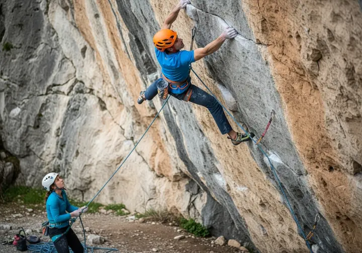
Imagine the moment. You’re standing at the base of a cliff that rises like a granite wave frozen in mid-break. The air is cool, scented with pine and chalk, and the only sound is the steady beat of your own pulse. In your hands is the climbing guidebook—pages dog-eared, margins scribbled with last season’s notes, a thin film of desert dust on the cover. At first glance it feels dense, almost aloof: numbers beside cryptic symbols, arrows arcing across photo-overlay topos, and tiny icons peppering the legend like an ancient script.
Yet when you learn its language, that same book becomes the most reliable partner you’ll ever rope up with. It tells you where the rock is solid, where the runout will make your palms sweat, and where a single cam placement can change the entire character of the pitch. Today we’re going to decode topos, interpret grades, and master the symbols and icons that turn a climbing guidebook from intimidating manual into actionable climb plan. By the time we’re done, the guidebook will no longer be mere data—it will be a map to confidence, safety, and a deeper relationship with the vertical world.
Pro-Tip: Before you leave the car, take ninety seconds to read the route description aloud to your partner. Hearing the words activates a different part of your brain and often surfaces questions you’ll be glad you asked before you’re halfway up a committing multi-pitch climb.
What Do the Numbers Mean? A Deep Dive into Climbing Grades

Why is a climbing grade more of a guideline than a rule?
A grade is a story told by the first ascensionist, filtered through their height, their reach, and the style they chose. What felt like a casual 5.9 slab to a six-foot-tall local accustomed to delicate footwork may feel like 5.10+ to a visiting boulderer who lives for overhanging power moves. Regions evolve their own accents. In the Shawangunks, a route established in 1958 and labeled 5.6 might spit you off if you expect modern bolts every six feet. The same holds true for the notoriously stout grades in Joshua Tree, where a 5.7 hand crack can feel like a sandbagged 5.9 until you learn the subtle knee-bar rest the first ascent party never thought to mention.
When locals mutter “old school,” they’re warning you that the grade carries historical baggage. Treat it as an invitation to dig deeper. Ask about the style, the protection, the day of the week the route was first led. The number printed beside the route name is not a verdict; it’s the opening line of a conversation that may last the rest of your climbing life.
How does the Yosemite Decimal System (YDS) work?
The Yosemite Decimal System (YDS) is the dialect spoken across the United States and Canada, but contrary to popular lore it did not originate in Yosemite Valley. In the 1950s, climbers at Tahquitz Peak needed a way to distinguish between casual scrambling and technical climbing, so they sketched five classes of terrain on the back of a topo. Class 1 was a sidewalk, Class 4 required hands, and Class 5 meant you had better bring a rope.
Class 5 soon swallowed the entire conversation. The scale opened like an accordion—5.9 was once the ceiling, until 5.10 appeared, then 5.11, and on and on until today’s elite routes tickle 5.15d. Each full number now splits into four slices: 5.11a, 5.11b, 5.11c, 5.11d. Those letters are subtle but vital; the jump from 5.11b to 5.11c can be the difference between a satisfying redpoint and a punishing whipper.
Protection ratings ride shotgun beside the grade. A 5.8 G means you’ll find bomber gear whenever you want it; a 5.8 R means you may cruise forty feet above your last piece wondering if the next horizontal will take a cam. An X rating is a polite way of saying “you could hit the ground or a ledge if you fall.” The American Alpine Club’s historical perspective offers a deeper look at how clean-climbing ethics shaped these designations. And if you want to compare YDS vs French grades, see a detailed comparison of YDS, French, and UIAA grades.
What are the other major global grading systems?
While YDS dominates North American cliffs, the rest of the planet speaks its own dialects. The French system—born on the sun-bleached limestone of Fontainebleau—uses a sleek alphanumeric scale: 6a, 7b+, 8c. The letter and plus sign add nuance, but the French scale focuses on overall pump and endurance rather than a single crux move.
Pro-Tip: When traveling, pick one foreign grading system and climb three routes at the same number before you let frustration set in. Your body needs time to recalibrate to new rock types, bolting ethics, and movement styles.
Across the Alps, the UIAA scale marches in Roman numerals: IV, V, VI+. The plus signs here feel stiffer than their French cousins, and the scale traditionally grades the hardest single move rather than sustained difficulty. The UK system adds a storytelling twist: every route carries two grades. The adjectival grade—Moderate, Difficult, Very Severe, E1, E5—describes the seriousness, the exposure, the quality of the rock and the protection. The technical grade—4c, 5b, 6a—pinpoints the hardest move. A route graded E1 5b could be safe but technical, while E4 5b might be easy moves above a fifty-foot runout.
Climbing Grade Conversion Chart
An interactive guide to compare the different sport climbing and bouldering grading systems.
YDS (USA)
5.5, 5.6, 5.7, 5.8
French (Sport)
4b, 4c, 5a, 5b
UIAA
IV, V-, V
UK (Technical)
4a, 4b, 4c, 5a
Australian
13, 14, 15, 16
Hueco (V-Scale)
VB, V0, V1, V2
YDS (USA)
5.9, 5.10a, 5.10b, 5.10c, 5.10d
French (Sport)
5c, 6a, 6a+, 6b, 6b+
UIAA
VI-, VI, VI+, VII-, VII
UK (Technical)
5b, 5c
Australian
17, 18, 19, 20, 21
Hueco (V-Scale)
V3, V4, V5
YDS (USA)
5.11a, 5.11b, 5.11c, 5.11d
French (Sport)
6c, 6c+, 7a, 7a+
UIAA
VII+, VIII-, VIII
UK (Technical)
6a, 6a
Australian
22, 23, 24, 25
Hueco (V-Scale)
V6, V7, V8
YDS (USA)
5.12a, 5.12b, 5.12c, 5.12d
French (Sport)
7b, 7b+, 7c, 7c+
UIAA
IX-, IX, IX+, X-
UK (Technical)
6b, 6c, 6c
Australian
26, 27, 28, 29
Hueco (V-Scale)
V9, V10
YDS (USA)
5.13a, 5.13b, 5.13c, 5.13d, 5.14a, 5.14b, 5.14c, 5.14d, 5.15a, 5.15b, 5.15c, 5.15d
French (Sport)
8a, 8a+, 8b, 8b+, 8c, 8c+, 9a, 9a+, 9b, 9b+, 9c
UIAA
X, X+, XI-, XI, XI+, XII-, XII, XII+
UK (Technical)
7a, 7a, 7a, 7b, 7b, 7b, 7c, 7c
Australian
30, 31, 32, 33, 34, 35, 36, 37, 38, 39
Hueco (V-Scale)
V11, V12, V13, V14, V15, V16, V17
When boulderers gather, they swap V-grades—V0 to V17—originating from John “Verm” Sherman’s Hueco Tanks guidebook. Europeans prefer the Fontainebleau scale, running 1A to 9A, each letter grade subdivided with plus or minus. Both systems describe short, intense movement, but the cultural flavor is distinct: think Texas campfire stories versus French café philosophy.
What do commitment and specialized grades tell you?
Beyond technical difficulty lies the dimension of seriousness. The NCCS grade, expressed in Roman numerals from I to VII, measures the overall commitment, not the moves. A Grade I sport route might be five minutes from the car, while Grade VI means you’re looking at a dawn-to-dusk—or multi-day—epic.
Aid routes speak the A and C scales. A1 means the rivets and copperheads feel solid; A5 means each piece is body-weight only and a fall could zipper the entire pitch. The C scale is the same game played “clean,” without hammering permanent gear. When winter arrives, ice climbers swap stories of WI5 pillars and M7 mixed monsters. Each system carries its own mythology, its own heroes and cautionary tales. And when the ice is in, you’ll want to study the specialized gear required for ice (WI) and mixed (M) climbing.
How Do You Read the Map of the Climb? From Sketch to Screen
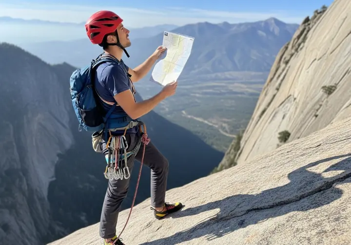
What exactly is a climbing “topo”?
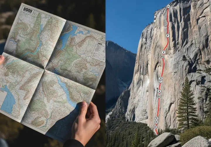
A climbing topo—short for topographical diagram—is not the same as the folded USGS topographic map tucked in your glovebox. Those maps depict broad landforms—ridges, rivers, and trailheads—at a scale measured in miles. A topo (climbing) is a magnifying glass held to the cliff face, a graphical representation of a climbing route that distills a three-dimensional wall into route lines, symbols, and annotations you can read at arm’s length.
The official USGS guide to topographic map symbols will remind you just how different those two worlds are.
How has the topo evolved with climbing?
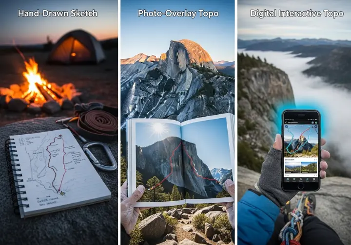
The earliest topos were campfire sketches—hand-drawn on the backs of paper placemats or inside spiral notebooks. They carried the quirks of their creators: a wobbly line for a dihedral, a tiny star to mark the crux, and insider tips scribbled in the margin. Those first ascent topos were art, memory, and invitation all at once.
In the late 1990s, publishers like SuperTopo and Rockfax began overlaying route lines on high-resolution photographs. Suddenly the modern topo looked exactly like the cliff you were staring at, and route-finding became intuitive. Today, apps like Mountain Project and Rakkup layer GPS breadcrumbs, user comments, and even short beta videos onto the photo-topo. The evolution moved from campfire myth to smartphone hypertext in a single generation.
Yet the principle remains the same: a good climbing topo translates the rock’s language into yours. And when you’re ten pitches up, wind whipping the pages, the topo becomes a critical navigational tool on a multi-pitch climb.
What Do All the Little Pictures Mean? Translating Guidebook Symbols
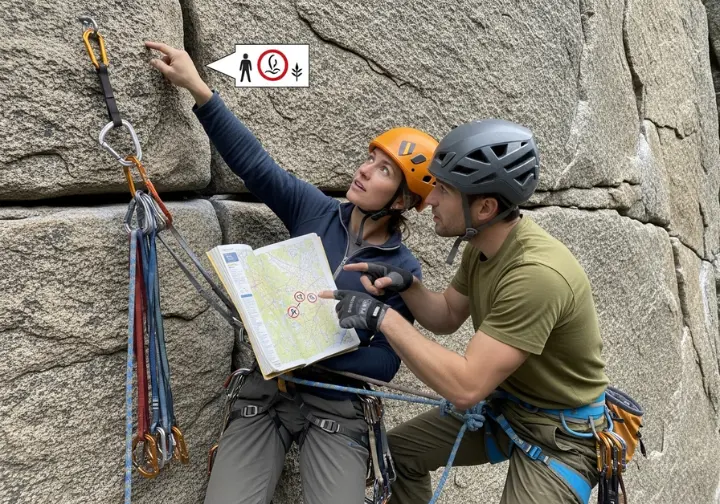
Is there a universal standard for symbols?
The UIAA, mountaineering’s international federation, has published a set of over thirty standardized symbols meant to serve as Esperanto on the world’s cliffs. Diagonals become dihedrals, circles mark bolted anchors, and a tiny lightning bolt warns of loose rock. These symbols and icons shine brightest in alpine venues and on big-wall climbs where language barriers and objective hazards demand clarity.
Yet even the UIAA symbols cannot cover every nuance. A dihedral in the Dolomites may feel different from one in Red Rocks, and local guidebook authors often add their own dialect. The key is to find the legend—usually printed on the inside cover or the first page—and treat it as your Rosetta Stone.
The official UIAA guide to topographic diagrams is the definitive source if you want to dive deeper.
When you spot the symbol for a belay station, cross-reference it with building a bombproof belay station to turn icon recognition into real-world skill.
How do different publishers use their own symbols?
Rockfax guides brighten the page with intuitive icons: a yellow sun for morning shade, a blue raincloud for storm shelter, a cartoon ghost for “spooky.” A flexing arm means the route rewards power; a star rating lets you know if the line is a beginner-friendly route worth queuing for. SuperTopo, born in Yosemite Valley, uses tiny diagrams to distinguish between knife-blade pitons and Lost Arrows—vital beta on big-wall leads where the wrong pin can skate right out of a shallow seam.
Indoor gyms swap paper for colored tape. A strip of blue tape marks the start holds; a matching piece at the top signals the finish. The language is simplified, but the grammar is the same: route line, grade, and style distilled into a code you read with your eyes and climb with your body.
And when you’re studying a complex big-wall topo like Freerider on El Capitan, those proprietary symbols turn abstract squiggles into a sequence of precise movements thousands of feet above the valley floor.
Why Is a Guidebook More Than Just Data? Understanding Its Soul and Impact
How do guidebooks create ethical challenges?
Every route description is an editorial choice. When an author awards five stars, traffic spikes. When a new parking lot appears at the trailhead, vegetation dies under boot soles. This is the “guidebook problem”: by centralizing information we also centralize impact. Some publishers have begun softening star ratings or omitting once-popular “Top 50” symbols to disperse the load. Others add safety notes about fragile cryptobiotic soil or seasonal raptor closures.
The antidote is stewardship. Treat every route description as an invitation to practice rigorously adhering to Leave No Trace principles. Pack out tape, stay on established trails, and if the parking area is full, consider that the crag’s way of asking for a day off.
How do I choose between a print book and a digital app?
Print guidebooks are tactile memory. The spine cracked open on a tailgate, coffee rings on the Red Rocks chapter, marginalia in your own handwriting reminding you to “bring extra #3s for the crux pod.” Buying a print guidebook is also a direct donation to the route developers who spent weekends scrubbing moss and replacing old/rusty bolts.
Digital apps trade nostalgia for immediacy. Real-time updates warn of access status changes, wildfire closures, or a fresh rockfall that altered yesterday’s approach time. GPS breadcrumbs guide you through a maze of desert fins when the sun drops faster than expected. And when you’re trying to decide whether to bring the 70-meter rope or the 60, a quick scroll through recent comments settles the debate.
Pro-Tip: If you must rely on a phone, screenshot every page you’ll need and save them to an offline folder. Batteries die faster in the cold, and nothing derails an alpine start like a dead screen at 4:30 a.m.
Most climbers now live in a hybrid world: plan at home with a fat, colorful tome; navigate on-route with a phone that holds downloaded PDFs or screenshots of the topo. Whichever format you choose, stay current with the most current information on access issues so your day ends with high-fives, not citations.
Conclusion: From Decoder to Confident Explorer
You now hold the keys to climbing guidebook literacy. You understand that a grade is a story, a topo is a map, and every symbol is shorthand for an experience waiting to unfold. You know how to weigh a YDS 5.9 R against a French 6a, how to read a Rockfax ghost icon and decide whether the spooky section is within your comfort zone, and how to balance the romance of print with the utility of digital.
The final step is action. Pick a route you’ve dreamed about—maybe the classic 5.6 hand crack that glows gold at sunset—and open the climbing guidebook. Read the description aloud. Trace the topo with your finger. List the gear list, the hazards, the walk-offs. Then fold the book, shoulder your pack, and walk to the base with the quiet confidence of someone who no longer just consumes information but translates it into actionable climbing plans, memory, and stewardship.
Frequently Asked Questions
What is the hardest climbing grade?
Currently, the hardest confirmed sport climbing grade in the world is 9c on the French scale (approximately 5.15d YDS), first established by Adam Ondra on his route “Silence.” For bouldering, the highest grade is V17 (9A Font), with “Burden of Dreams” being the first of this grade.
What does it mean when a climb is “sandbagged”?
“Sandbagged” is a climbing slang term for a route that feels significantly harder than its official grade suggests. This often occurs in older climbing areas where grading systems were different, or it can reflect the unique style or strengths of the first person who graded it.
Are digital guidebooks like Mountain Project replacing print guidebooks?
While digital guidebooks are incredibly popular for their convenience and real-time updates, they are not completely replacing print guidebooks. Many climbers prefer print guidebooks for planning, inspiration, and reliability in areas without cell service, and buying them directly supports the authors and local climbing communities who do the work of developing routes.
Risk Disclaimer: Rock climbing, mountaineering, and all related activities are inherently dangerous sports that can result in serious injury or death. The information provided on Rock Climbing Realms is for educational and informational purposes only. While we strive for accuracy, the information, techniques, and advice presented on this website are not a substitute for professional, hands-on instruction or your own best judgment. Conditions and risks can vary. Never attempt a new technique based solely on information read here. Always seek guidance from a qualified instructor. By using this website, you agree that you are solely responsible for your own safety. Any reliance you place on this information is therefore strictly at your own risk, and you assume all liability for your actions. Rock Climbing Realms and its authors will not be held liable for any injury, damage, or loss sustained in connection with the use of the information contained herein.
Affiliate Disclosure: We are a participant in the Amazon Services LLC Associates Program, an affiliate advertising program designed to provide a means for us to earn advertising fees by advertising and linking to Amazon.com. As an Amazon Associate, we earn from qualifying purchases. We also participate in other affiliate programs. Additional terms are found in the terms of service.

